V.N. Sukachev Institute of Forest  
Laboratory of Ecophysiology of Permafrost Systems  


About our project

Work packages

Staff

Field sites

Equipment

Activities

Publications

Contact

Study Site Samoylov Island
(the central Lena River Delta at 72°22′N, 126°29′E)

Biome: Tundra
Permafrost regime: Cold (-8.9°C at depth of 27 m below the active layer) and the zone of continuous permafrost with permafrost depths ranging from 400–600 m
Parent material: Samoylov Island is located on the first terrace (the main geomorphological unit in the Lena River Delta), and consists of a flood plain in the west and an elevated river terrace in the east that is characterized by polygonal tundra. This terrace formed during the Holocene and occupies most of the central and eastern parts of the delta.
Mean annual temperature: -12,5°C; mean annual precipitation: 200 mm
Soils (Soil Survey Staff, 2010): Gelisols, Entisols
Vegetation:

The overgrown parts of the flood plain are characterised by the Salix-Equisetum-Alopecurus alpinus community, dominated by willow shrubs (Salix glauca, S. lanata and S. reptans), horsetail (Equisetum), Poaceae (Alopecurus alpinus, Festuca rubra, Deschampsia borealis) and Tanacetum bipinnatum.
The dry tundra is dominated by the moss species Hylocomium splendens, together with Dryas punctata, Polygonum viviparum, Astragalus frigidus, with willow shrubs (Salix glauca, S. lanata and S. reptans, S. reticulata), and lichens (Peltigera) belonging to the Hylocomium splendens Dryas punctata-lichen community.
The vegetation of the wet tundra is made up of the Drepanocladus revolvens-Meesia triquetra-Carex chordorrhiza community (i.e., the hydrophilic mosses Drepanocladus revolvens, Meesia triquetra, and Calliergon giganteum), the sedge Carex chordorrhiza, marsh cinquefoil (Comarum palustre), sudetic lousewort (Pedicularis sudetica), and others.

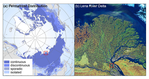
Fig. 1. (a) Circumpolar permafrost distribution (Brown et al., 1998) and the Lena River Delta. (b) Location of the Samoylov study site within the Lena River Delta, Eastern Siberia (NASA, 2000)

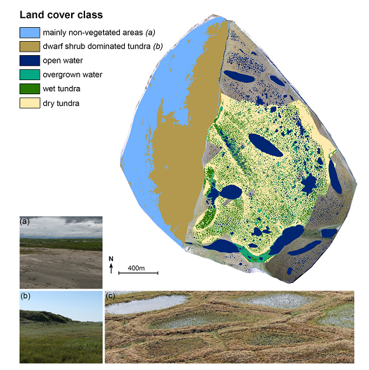
Fig. 2. Land cover classes on Samoylov Island. Classification of the eastern part of the island is based on Muster et al. (2012). The western part, which is non-vegetated or dwarf shrub tundra, is subject to flooding by the Lena River during spring. Overgrown water and wet and dry tundra were only classified for a subset of the terrace. The classification is overlain on the 2007 VIS orthophoto (grey colour) (Boike et al., 2013).

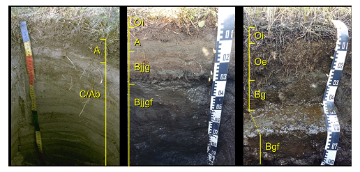
Fig. 3. Photos of three typical soils at Samolyov Island. (a) Typic Psammorthel, floodplain, natural levee, 2001; (b) Typic Aquiturbel, first terrace, polygon rim, 2012; (c) Typic Historthel, ?rst terrace, polygon centre, 2012 (Boike et al., 2013).

Sources of information:

Boike, J., C. Wille, and A. Abnizova (2008), Climatology and summer energy and water balance of polygonal tundra in the Lena River Delta, Siberia, J. Geophys. Res., 113, G03025, doi:10.1029/2007JG000540.

Boike, J., Kattenstroth, B., Abramova, K. et al. (2013) Baseline characteristics of climate, permafrost and land cover from a new permafrost observatory in the Lena River Delta, Siberia (1998-2011) / Biogeosciences, 10, 3, 2105-2128,DOI: 10.5194/bg-10-2105-2013