
Institute of Forest
II
CONFERENCE OF YOUNG SCIENTISTS
April 15-16, 2003, Krasnoyarsk
V. N. Sukachev Institute of Forest SB RAS
Organized by:
Siberian International
Centre for Ecological Research of Boreal Forests,
V. N. Sukachev Institute of Forest, Russian Academy of Sciences
Siberian Branch
ESTIMATION OF THE STATE OF ANTHROPOGENEOUS FOREST ECOSYSTEMS
A. I. Bouzikin, L. S.
Pshenichnikova, I. S. Dashkovskaya
V. N. Sukachev Institute of Forest, Russian Academy of Sciences, Siberian
Branch, Krasnoyarsk, Russia
The flowing monitoring
by ground and long distance methods most efficiently taps sharp and contrast
modifications of forest ecosystems state after cuttings, fires, invasion
of insects. It is possible to discover the cumulative effect of long-lived,
but weak actions only by methods of early diagnostics and retrospective
analysis. Under influence of long-lived antropogeneous action south Siberian
ecosystems have changed. The square of forests decreases as a result of
using for agriculture needs. The natural native forests change on antropogeneous.
Coniferous breeds: a pine, larch, fur, Siberian pine are replaced for
birch and aspen. Structure of forests has changed because of bushes, grassy
and forest meadows diffusion. The forest productivity is reduced. The
majority of southern taiga subzone forests have the real productivity
of derivative forests 1,5-3 times less than native forests, that testifies
to incomplete usage of environmental resources.
Methods of current monitoring do not reflect historical process of shaping
antropogeneous forest ecosystems. These methods reflect only last modifications,
and do not take into account long-lived process of ecosystems transformation.
Therefore usage of modern methods of monitoring can be efficient in combination
with special retrospective monitoring methods taking into account historical
antropogeneous ecosystems transformation. We have to use a combination
of flowing and retrospective monitoring for sustainable forestry, and
for prognoses of forest complex development. The productive forests utilized
and involve in a cycle 2-3 times more solar energy and carbon dioxide
in comparison with degraded forests.
The study is supported by Russian Foundation of Basic Research (Grant
No 01-04-48176).
CARBON EMISSION ESTIMATION ON CLEARCUT BURNING
A. V. Brukhanov, S.
V. Verkhovets
V. N. Sukachev Institute of Forest, Russian Academy of Sciences, Siberian
Branch, Krasnoyarsk, Russia
The area of clearcuts without reforestation increases in Siberia annually. Surface fuel load on these areas is very high and may reach up to 120 t/ha. 70% of fires regularly occur in these areas and have tremendous effect in carbon balance. Studies have been carried out on clearcuts in coniferous forests of Low Angara Region, Yenisey Rage and East Sayan. Estimation of biomass consumption in fire under fire danger class III-IV shows that carbon emissions are equal to 20-28 t/ha, under fire danger class V - 30-35 t/ha. Carbon load preserved by fire is 15-35 t/ha. Postfire carbon storage depends on success of reforestation determined by vegetation type (Calamagrostis grasses or fireweed domination) and seed sources presence.
EDGE DETECTION ON AEROSPACE IMAGES FOR THE FORESTED TERRITORIES
A. A. Buchnev, V. P.
Pyatkin, G. I. Salov
Institute of Computational Mathematics and Mathematical Geophysics, Russian
Academy of Sciences, Siberian Branch, Novosibirsk, Russia
Successful decision of a wide number of actual problems in the analysis of aerospace images related to the forested territories depends on edge detection technique employed. For many applications, present methods of edge defection are not sufficient and complete yet because these often use subjective approaches. Therefore, for such complicated objects like the boreal forests, the development of other approaches based on the mathematical tools and automated technique is an actual task. For solving this problem, a statistic approach has been suggested. The bases of this approach lie in using the nonparametric statistic criteria. A few examples of developing corresponding software and its implementing in practice have been demonstrated. In addition, this approach was validated while edging some characteristic features on the images related to the forest area.
GEOINFORMATION TECHNOLOGY
OF ASSESSMENT OF OIL
EXTRACTION IMPACT ON SWAMP-FOREST ECOSYSTEMS BY MEANS
OF MIDDLE RESOLUTION SPACE IMAGES
I. V. Bulgakova, Y.
M. Polichtchouk, O. S. Tokareva
Institute of Petroleum Chemistry Russian Academy of Sciences, Siberian
Branch, Tomsk, Russia
Methodical problems
of analysis of atmosphere pollution impact on forest ecosystems bymeans
of geoinformation systems and remote sensing data are developed. Landscape
structure of oil production territories in southern part of West Siberia
are determined on base of procession of space images from spaceborn Resource-O.
Particularities of atmosphere pollution zones modelling caused by gas
burning in torches on territories of oil fields are considered. Pollution
zones were revealed by modelling of contaminants dispersal in atmosphere
with standard models. Polluted landscapes squares are calculated depending
on oil production volume.
The study is supported by EC INCO Copernicus 2 Programme (Project ISIREMM,
contract ICA2-CT-2000-10024) and INTAS (Project ATMOS: A Scientific WWW
Portal for the Atmospheric Environment, contract INTAS-00-189).
VARIABILITY OF GENETIC
SYSTEM OF PINUS SYLVESTRIS L.
UNDER INFLUENCE OF NATURAL-CLIMATIC AND ANTHROPOGENIC FACTORS
A. K. Butorina, V. N.
Kalaev
Voronezh State University, Voronezh, Russia
Pinus sylvestris is one of the mainl trees species in boreals forests. The increase of genome size was typical of the populations of pine from Karelia, Tumen and Ekaterinburgh regions which were investigated by us as compared with Voronezh population (from Central Russia) which is on the boundary between forest and step. Apparently this may be due to duplications of some DNA sequences as addition to general way of genome increasing during evolution of genus Pinus by "secret polyploidy" [Price, 1976]. In the same north pine populations the increasing of nucleoli number (to 12) was also noted comparing with Voronezh population where their number was equal to 4 - 6. However under anthropogenic contamination here the nucleoli number is increased also and in some cases the phenomenon of "persistent nucleoli" at the stages of metaphase - telophase and in cytoplasm of interphase cells was observed. It was noted in pine by us for the first time. Such increasing of nucleolar activity in pine growing on the boundary boreal forest under contaminated conditions may be considered as mechanism of its adaptation to worsening of environment because it may be evidence of increasing of its metabolism. The north populations will be more vulnerable to anthropogenic contamination because they exist on the limit of their own possibilities to use available cytogenetic mechanisms of adaptation.
THE IMPACT OF FIRE
ON KRASNOYARSK FOREST-STEPPE PINE STANDS
THINNING AND GROWTH
V. A. Bychkov, S. V.
Verkhovets, Y. K. Kisilyakhov, V. V. Kuzmichev
V. N. Sukachev Institute of Forest, Russian Academy of Sciences, Siberian
Branch, Krasnoyarsk, Russia
Post surface fire studies
have been carried out in pine stands of Krasnoyarsk forest-steppe. Data
from 6 permanent plots arranged in V. N. Sukachev Institute of Forest
Experimental Station "Pogorelsky Bor" have been used for long-term
forest growth studies. In addition 19 temporary plots have been set. It's
established that the average stand parameters are similar to growth rate
table ones of forest site class II for Achinsk-Krasnoyarsk forest-steppe
zone. There are no significant differences in height growth of stands
with and without surface fires. Average diameters of trees on stands with
surface fire are higher than on ones growing without fire. Basal area
and wood stock of compared stands differ significantly.
Thinning has less effect on stand density than moderate and high intensity
surface fires, so restoration of basal area and wood stock happens faster
due to less destruction of biocenosis relationships. Used thinning practice
results in slowing down of best trees growth. But thinning by surface
fire has such positive results as increased diameter growth and fast commercial
timber storing, low fire hazard due to small fuel load, formation of park-like
semi-opened stands.
DETERMINATION OF
THE MULTIELEMENT COMPOSITION
OF FOREST COMBUSTIBLES AND SOILS OF SIBERIAN BOREAL FORESTS
O. V. Chankina1, G.
A. Kovalskaya1, T. I. Savchenko1, K. P. Koutzenogii1,
G. A. Ivanova2, P. A. Tarasov3
1Institute of Chemical Kinetics and Combustion, Russian Academy of Sciences,
Siberian Branch, Novosibirsk, Russia; 2 V. N. Sukachev Institute of Forest,
Russian Academy of Sciences, Siberian Branch, Krasnoyarsk, Russia; 3Siberian
State Technological University, Krasnoyarsk, Russia
Forest fires have powerful effect on forest ecosystems. Vegetation organisms are sensitive to the composition of the environment and their element composition actively responds to a change in its state. This paper reports on the multielement composition of forest combustibles and soils of the ecosystem of the boreal forests of the Krasnoyarsk region. The results are given for a change in the element composition of forest bedding and soils after the test burning of a concrete experimental region. The multielement composition of samples is determined using the X-ray fluorescence method of synchrotron radiation (SRXRF). The concentrations of 28 elements were found: K, Ca, Ti, V, Cr, Mn, Fe, Co, Ni, Cu, Zn, Ga, Ge, As, Se, Br, Rb, Se, Y, Zr, Nb, Mo, Ba, Hg, Pb, Bi, Th, U. The results obtained can be used to estimate changes in the element composition of forest biocenosis subjected to a forest fire.
LONG-TERM STATIONARY
ECOLOGICAL AND GEOGRAPHIC RESEARCH
IN NEAR ANGARA REGION SOUTHERN TAIGA: FUNCTIONAL FEATURES
OF TREE GROWTH, RECONSTRUCTIVE FOREST DYNAMICS, EQUILIBRIUM ECOSYSTEMS
STATES AND FACIAL CONDITIONS CLASSIFICATION
A. K. Cherkashin S.
V. Solodynkina
Institute of Geography, Russian Academy of Sciences, Siberian Branch,
Irkutsk, Russia
The results of ecological
and geographic stationary investigation at long-time research station
in the Near Angara region taiga (1962-2002) are represented. Special attention
is paid to the dynamics analysis of undisturbed dark-coniferous taiga
forests on station transect. The new regularities of restocking, growth
and death for trees in polydominant stands in different geographic situations
(facies) are detected. Regularity of reconstructive forest dynamics and
modern equilibrium ecosystems states formation in various facies factorial-dynamic
series are described. The earliest version of natural classification of
southern taiga Near Angara region facies is constructed by principles
of spatial and system organization. The attempt is made to link classification
geosystems position with the characteristics of intensity and direction
for reforestation processes.
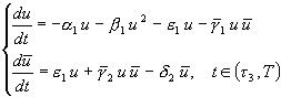
The obtained knowledge is used for perfecting mathematical model equations
of forest dynamics. The system of first-order differential equations in
partial derivatives depicted temporal changes of trees distribution on
diameter r in unit zone near point ![]() with coordinates (x, у) for species i is used:
with coordinates (x, у) for species i is used:
![]()
where l is the number
of forest forming species within considered site; ![]() is the number of i species trees in unit zone of a point with coordinates
is the number of i species trees in unit zone of a point with coordinates
![]() and
and ![]() ;
;
![]() and
and ![]() correspond to intensity of death and growth rate of trees; N is the general
thickness of stand;
correspond to intensity of death and growth rate of trees; N is the general
thickness of stand; ![]() is the number of the trees with diameter
is the number of the trees with diameter ![]() at the moment t near a point
at the moment t near a point ![]() that were cut down or planted in a unit of time. The solution (1) is found
at initial
that were cut down or planted in a unit of time. The solution (1) is found
at initial ![]() and boundary
conditions which determin intensity of seed and seedling renewal for stands
in various environmental conditions. The functional connections simulation
technique, based on congruencies models, allows us to describe various
connections of ecosystems parameters in the same language. The coefficients
determined are indicators of environment properties and depend on the
classification position of studied objects.
and boundary
conditions which determin intensity of seed and seedling renewal for stands
in various environmental conditions. The functional connections simulation
technique, based on congruencies models, allows us to describe various
connections of ecosystems parameters in the same language. The coefficients
determined are indicators of environment properties and depend on the
classification position of studied objects.
A MODEL OF FOREST
SOIL ORGANIC MATTER DYNAMICS (ROMUL)
TO SOLVE PROBLEMS OF CARBON BALANCE AND PRODUCTIVITY
IN FOREST ECOSYSTEMS
O. G. Chertov1, A. S.
Komarov2, M. A. Nadporozhskaya1, S. S. Bykhovets2, S. L. Zudin2
1St. Petersburg State University, Oranienbaum, St. Petersburg, Russia;
2Institute of Physico-Chemical and Biological Problems of Soil Science,
Russian Academy of Sciences, Pushchino, Russia
The model of soil organic matter (SOM) dynamics in forest ecosystem (ROMUL) is based on data on litter decomposition in controlled conditions. It has arbitrary number of litter fall cohorts and corresponding number of SOM cohorts: undecomposed litter, partly humified organic material, and stable humus bonded with the mineral matrix. There are three processes of SOM humification by three communities of organisms-destructors and three processes of SOM mineralization. The model is represented by a system of ordinary differential equations with coefficients that depend on soil temperature and moisture, litter nitrogen and ash content, and on the C/N ratio in the mineral topsoil. The model also calculates carbon dioxide evolution and nitrogen mineralization for plant growth. The model has been validated and used for estimation of SOM dynamics and carbon balance in different conditions. It was also used as soil compartment in forest ecosystem models.
FUSION OF THE MULTISPECTRAL
AND RADAR DATA FOR THE FOREST
CLASSIFICATION IN THE LAKE BAIKAL REGION
T. N. Chimitdorzhiev,
S. Y. Tsitsiktuev, S. G. Shapkhaev, V. A. Dandarov
Buryatia Science Center, Russian Academy of Sciences, Siberian Branch,
Ulan-Ude, Russia
For the Lake Baikal area, a new approach to the problem of reserved forests classification has been proposed on the basis of fusion of multispectral optical and radar data fusion. Some examples of classification of the forested areas with anthropogenic impact are presented. Significant improvement in classification accuracy has been achieved due to proposed technique, which can be extended to other territories in Siberia.
FIRE IN BOREAL ECOSYSTEMS: A KEY PROCESS IN GLOBAL AND REGIONAL ECOLOGY, CARBON CYCLES, AND ATMOSPHERIC CHEMISTRY
S. G. Conard
USDA Forest Service, Washington, USA
Fire is one of the dominant
disturbance processes in the boreal zones of Russia, Canada, and the US.
As an ecological process it affects vegetation dynamics, productivity,
stocks of harvestable timber and other forest products, wildlife populations,
erosion and water quality, nutrient and carbon cycling and storage, and
soil biological processes. Fire impacts regional air quality and releases
gases and aerosols to the atmosphere that affect visibility, transportation
systems, and the atmospheric forcings that contribute to global environmental
changes. Validated methods for monitoring and quantifying the extent,
frequency, and severity of fire in these systems, as well as understanding
of the underlying biophysical processes, are critical for understanding
the impacts of wildland fires in these systems, and the potential impacts
of changes in fire management, natural or human ignition patterns, and
regional or global climate on these fire regimes.
A number of national and international research programs are working on
aspects of this problem, and general estimates of burned area are being
improved and validated in Russia, US, and Canada. These efforts are beginning
to focus on methods for quantifying fire severity over large regions.
Other important steps in improving estimates of ecosystem and atmospheric
effects of fire are the classification of burned areas according to fuel
types or forest types where fires are occurring, development of emission
factors and fuel consumption data for the most important fuel types, and
improved understanding of the factors affecting fire behavior and fire
severity and their effects on ecosystem response. An important foundation
for all of this work will be improved understanding of biophysical processes
and human factors that affect fire regimes and fire effects.
VALIDATION OF MODIS
ACTIVE FIRE PRODUCTS IN SIBERIA
WITH COINCIDENT ASTER DATA
I. Csiszar1, J. Morisette2,
L. Giglio2, Ch. Justice1
1University of Maryland, Maryland, USA; 2Goddard Space Flight Center,
NASA, Greenbelt, USA
Satellites provide valuable information for the large-scale monitoring of biomass burning in the vast boreal forest region. However, the accuracy of the satellite-derived fire products needs to be determined. An active fire product from the Moderate Resolution Imaging Spectroradiometer (MODIS) instrument on board the polar orbiter Terra satellite has been available since 2000. A unique feature of the Terra satellite is the availability of coincident high resolution data from the Advanced Spaceborne Thermal Emission and Reflection Radiometer (ASTER). In this study we used the elevated signal in the 30 m resolution ASTER channel 9 at 2.4 µm to characterize fires within the 1-km MODIS pixels. The probability of MODIS detection was determined by logistic regression as a function of sub-pixel fractional fire coverage and spatial heterogeneity. Examples of individual fires and summarized statistics will be presented for May and August 2001 cases in Siberia. The effects of algorithm changes on product accuracy will also be discussed. This work is being undertaken in the framework of the international GOFC/GOLD-Fire program. Involvement of regional scientists in validation of satellite data products is encouraged and will help build a user community informed on the capabilities and limitations of a given product for susbsequent application.
DATABASE AND ATLAS
OF MAPS OF RADIOREFRACTIONAL PROPERTIES
OF ATMOSPHERE ABOVE THE TERRITORY OF COMMONWEALTH
OF INDEPENDENT STATES
D. D. Darizhapov, E.
V. Batueva
Department of Physical Problems, Russian Academy of Sciences, Siberian
Branch,
Buryat Science Centre, Ulan-Ude, Russia
Refractional properties
of atmosphere render essential influence on functioning of radioelectronic
systems, including for work of radar-tracking complexes of various basing,
including space-born. From this point of view drawing up the database
and maps of radiometeorological parameters of atmosphere is a rather urgent
problem and promotes increase and improvement of an overall performance
of systems.
On the basis of the database the information on materials of long-term
aerologic supervisions for uniform ten-year period (1961-1970) is incorporated
on 146 stations of aerologic radiosounding. Average meanings of temperature,
pressure and humidity, and also their standard deviations at different
high-altitude levels up to 3000 м in readout from a level of station,
grouped on all months of a year and on terms of days make the separate
block of the specified database. The second block of the database contains
average values of the radio refractive indexes for radiowaves and values
of their standard deviations. In the separate, third block of the database,
average values of vertical gradients of the refractive index and their
standard deviation in various on capacity tropospheric layers with various
heights of the bottom border of a layer are shown.
The database system MS FoxPro is chosen for realization of relational
model. This database system has necessary software of creation, accumulation
and running the database. The block of isolines maps of atmosphere's refractive
indexes on the basis of the database of radiometeorological parameters
of ground atmosphere is constructed. The block contains 20 maps describing
spatial distribution of average and root-mean-square of deviations of
ground values N in various times of days of central months of four seasons
of a year and 4 maps describing monthly average values of considered parameters.
Average values of vertical gradients N and their standard deviations are
designed in ground layers 0~300 м, 0~600 м, 0~900 м, 0~1500 м, 0~2000
м and 0~3000 м, in raised layers 300~600 м, 300~900 м, 300~1500 м, 300~2000
м, 300~3000 м, and also in layers higher than 600 and 900 m. By results
of these calculations the appropriate maps of isolines describing various
seasons of a year and times of days are constructed.
STATUS OF THE NORTHERN
EURASIA EARTH SCIENCE PARTNERSHIP
INITIATIVE (NEESPI)
D. W. Deering
Goddard Space Flight Center, NASA, Greenbelt, USA
The Northern Eurasia Earth Science Partnership Initiative or NEESPI is a planning strategy that has the goal of establishing a large-scale, interdisciplinary program of funded research aimed at developing a better understanding of the interactions between the ecosystem, atmosphere, and human dynamics in northern Eurasia in support of international science programs with particular relevance to Global Climate Change research as well as the concerns that face national and international decision-makers of the partnering countries. The intent is to build upon existing international science programs and facilitate critical collaborative studies that have need of international science community participation. Early objectives of the NEESPI have been to determine the mutual interests among several Russian and U.S. research organizations and to jointly develop a strategy for proceeding with formal planning. Key U.S. and Russian government leaders and scientists, who can address Earth science priorities, funding potentials, socio-political merits, and implementation issues have been involved to date, and engagement of similar representatives from other interested countries and international research programs is being sought. Products that will result from initial activities organized and supported by the leadership of the NEESPI include elucidating the central science themes and formulating the critical science questions, establishing parameters for the partnership program of scientific research, securing funding for essential developmental activities, developing a preliminary science plan and joint projects, establishing a timetable for the preparatory and implementation phases, and determining what type of organizational structure is needed for the program of research and management of the NEESPI.
LEAF AREA INDEX FOR
FIRE CHRONOSEQUENCES IN POST-FIRE
SIBERIAN BOREAL FOREST
D. W. Deering1, A. H.
Conley1, V. I. Kharuk2, A. G. Nelzina3, G. B. Kofman2,
L. N. Skripalschikova2, V. V. Kuzmichev2
1Goddard Space Flight Center, NASA, Greenbelt, USA; 2V. N. Sukachev Institute
of Forest, Russian Academy of Sciences, Siberian Branch, Krasnoyarsk,
Russia; 3Krasnoyarsk State Technological
University, Krasnoyarsk, Russia
The study of leaf area
index (LAI) can provide important information about ecosystem function
and processes as green leaves have significant role in many biological
and physical processes of plant canopies. LAI can serve as a measure of
photosynthetic capacity, gas exchange, and heat fluxes. The need for determining
LAI at broad scale has been identified by such programs as the Earth Observing
System (EOS), which seeks to develop and validate algorithms that estimate
leaf area index among other ecosystem characteristics from remotely sensed
data.
We focused our study on LAI across a post-fire chronosequence and on the
development of algorithms to link LAI derived from surface measurements
with remotely sensed data. Field campaigns were conducted in 1999, 2000
and 2001 to establish sites and to collect surface measurements of LAI
as well as a number of general forest characteristics in mixed dark-coniferous
boreal forest. Satellite data, including images from Landsat-7 and IKONOS,
were obtained in 2000 and 2001. In the course of our research we obtained
indirect (via optical instruments LAI-2000, TRAC), direct (destructive
sampling) and remotely sensed estimates of LAI for four post-fire stand
ages (0-2, 13, 25, and 100+ years since fire).
THE EVOLUTION OF LARCH IN STRUCTURE OF SIBERIAN BOREAL FORESTS DURING THE HOLOCENE
G. A. Demidenko, E.
V. Koteneva
Krasnoyarsk State Agricultural University, Krasnoyarsk, Russia
Larch was changing its composition in structure of forest-forming species of Siberian boreal forest during the Holocene climatic periods. Predominance of larch is connected with the post-glacial epoch`s conditions, larch did't demand much heat and moisture and could grow on the cold soils. Larch was prevailing during the warm periods of the Holocene with the fires too because it grew in regions of burned dark-coniferous forests. Larch prevailed on the territory of modern sub-zone of the middle and south taiga during the Pre-Boreal, Boreal, the first half of the beginning of the Sub-Boreal periods. The rest of time it was an accompanying genus.
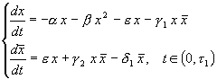
MODEL OF CHORISTONEURA FUMIFERANA POPULATION DYNAMICS
J. K. Denisova1, L.
V. Nedorezov1, S. A. Bakhvalov2
1Institute of Molecular Biology and Biophysics, Russian Academy of Medical
Sciences, Siberian Branch, Novosibirsk, Russia; 2Institute of systematic
and ecology of animals, Russian Academy of Sciences,
Siberian Branch, Novosibirsk, Russia
At present paper there
is the consideration of Choristoneura fumiferana population dynamics
which is based on the system of ordinary differential equations with impulses.
It's assumed in the model that there are two main regulators (self-regulation
and pathogens), which have influence on the population dynamics (onto
the changing of larvae number):
 ,
, ![]() ,
,
![]() ,
, ![]() ,
,
![]() ,
, ![]() ,
,
 ,
, ![]()
where ![]() is a number of healthy young larvae,
is a number of healthy young larvae, ![]() is a number of sick young larvae,
is a number of sick young larvae, ![]() is
a number of pupae,
is
a number of pupae, ![]() is a number of butterflies,
is a number of butterflies, ![]() is a number of healthy old larvae,
is a number of healthy old larvae, ![]() is a number of sick old larvae,
is a number of sick old larvae, ![]() are the coefficients of natural death rates,
are the coefficients of natural death rates, ![]() are the coefficients of self-regulation, are the coefficients of transmission
process for individu-als from one state to another,
are the coefficients of self-regulation, are the coefficients of transmission
process for individu-als from one state to another, ![]() are the intervals of length of the phases of insect development,
are the intervals of length of the phases of insect development, ![]() is a coefficient of productivity,
is a coefficient of productivity, ![]() is a quota of survived individuals during the winter period.
is a quota of survived individuals during the winter period.
As it was found for model if the following inequality is realized:
![]()
population eliminates under all possible initial conditions. Under the numerical analysis it was found that in model the cyclic regimes of population dynamics could be realized. If the influence of pathgenes is absent in a model there are regimes of asymptotic stabilization, which can be realized under all initial conditions.
THE COMPARATIVE DENDROCHRONOLOGICAL
RESEARCH
AT THE TRANSECTS IN THE SOUTH OF ARKHANGELSK REGION
AND IN CENTRAL MESHCHERA
K. N. Diakonov, A. I.
Beliakov
Moscow State University, Moscow, Russia
Increment cores and
stem disks of Pinus sylvestris and Picea abies were collected along the
lines of local landscape transects located in the middle-taiga subzone
in the South of Arkhangelsk Region and in the mixed forests zone in the
center of Meshchera lowland (North of Ryazan region). The distance between
transects is about 650 km from the North to the South. Cores and stem
disks were scanned, the tree rings were digitized by image editor, and
their width was calculated semi-automatically. For each site (geosystem
of low hierarchical level) the samples collected were crossdated, the
age-related trends were minimized and the final series were grouped by
simple averaging. The correlation and synchronous coefficients among the
tree-ring series of each geosystem of both regions were then calculated.
High correlation (0.85) and synchronous (91 in series 1969 - 1981) coefficients
were found between the series of increments in plain geosystems of watersheds
with Polytrichum commune and sod-podzolic-gley soils of both regions.
Correlation between the increments at other sites is not high, but maximums
of increment during 1975-1976 and 1989-1990 were also detected in both
regions and at every site. This provides sufficient evidence to assert
that the global processes had equally profound impact on similar geosystems
in the studied regions, regardless of their geographical proximity.
COENOPOPULATION STRUCTURE
OF SOME PIONEER SPECIES
ON THE LITTLE ICE AGE MORAINE COMPLEX
M. N. Dirks
Tomsk Branch of V. N. Sukachev Institute of Forest, Russian Academy of
Sciences,
Siberian Branch, Tomsk, Russia
Ice-free glacier young
moraine complexes gradually have been settled by plants, before all pioneers
and their coenopopulations appeared. In 2000 Crepis nana Richards. and
Saxifraga oppositifolia L. s. str. coenopopulation structure on the Maly
Actru glacier Little Ice Age moraine complex (Severo-Tchujsky khrebet,
Altai) were studied. Given plants are pioneers on ice-free territories
within the Altai and Sajan Mountains [Revjakina, 1996], Saxifraga oppositifolia
is like that within the Austrian Alps [Zollitsch, 1969]. Individuals grow
all over the moraines from the youngest 3 years glacier-free areas with
undeveloped vegetation to the end moraine of the middle of XIX century
with the close cover areas.
Pioneer coenopopulations on the 3-7 year ice-free area are a normal type,
and young and include all members. On the final moraine coenopopulations
are a normal type, include all members with the regression signs. Crepis
nana coenopopulation on the 23-27-year ice-free area has the highest density,
on the 3-7 year territory it has the lowest density. Saxifraga oppositifolia
coenopopulations have a very low density - less than one individual per
0,25 m2.
RESEARCH OF ELECTRODYNAMIC
PARAMETERS
OF EAST SIBERIAN FORESTS
B. Ch. Dorzhiev
Department of Physical Problems, Russian Academy of Sciences, Siberian
Branch,
Buryat Science Centre, Ulan-Ude, Russia
In this work results of research of electrodynamic properties of forest mediums in a wide range from meter up to centimetric waves is submitted. The results of the research will be used for properties of radar-tracking data, that will allow us best to solve such problem, as space-born of forests. Subject of research is forests of East Siberia as the least investigated in this case and has specific biomorphological characteristics. During the research the complex approach, including joint using of satellite data, ground radiophysical research and natural materials on test sites, is applied.
ALTITUDINAL BELT
COMPLEXES OF ECOSYSTEMS ON THE PROFILES-TRANSECTS IN THE SAYAN RIDGES
(ACCORDING TO THE DATA
OF REMOTE SENSING)
O. V. Drobushevskaya1,
A.T. Dutbayeva2, M. E. Konovalova1, E.V. Fedotova1
1V. N. Sukachev Institute of Forest, Russian Academy of Sciences, Siberian
Branch, Krasnoyarsk,
Russia; 2Reservation "Stolby", Krasnoyarsk, Russia
The key level of land cover differentiation in mountains of Altaj-Sayan is the level of altitudinal belt complex of biogeocoenoses [Smagin et al., 1980] or belt ecosystem, BEC. Classes of BEC represent a zonal level of land cover subdivision in mountains. The reality of these categories became obvious since 1990 when sattelite images NOAA/AVHRR revealed the spectra of BEC on the macroslopes of the ridges. The profiles-transects established in the East and West Sayan ridges along the road Krasnoyarsk-Abakan-Kysyl allow us to observe a great diversity of BEC, from dry steppe up to high mountain woodlands and tundra. For comparative analysis we attracted the data of the field works, AVHRR images and composites, published maps and forest inventory data. Comparison of the data shows that it is important to evaluate thoroughly any revealed boundary to interpret remote sensing data. To determine the leading factor it is reasonable to analyze the pattern of landscape components on transects and maps.
INTERANNUAL DYNAMICS
OF SNOW-COVER AND VEGETATION GREENNESS
IN NORTHERN EURASIA
D. G. Dye
Frontier Research System for Global Change, Yokohama, Japan
Separate satellite-based studies have reported two distinct eco-climatological trends in high latitude Northern Hemisphere land areas over recent decades: a trend toward an earlier, longer and 'greener' active growing season, and a trend toward earlier disappearance of snow-cover in the spring season. This study employs satellite-derived observations to examine interannual variability and trends in vegetation greenness and the annual snow-cover cycle in northern Eurasia land areas, and their relation to one another during the period from 1984 to 1999. The results provide insight to the significance of a changing snow-cover regime for vegetation growth activity and the terrestrial carbon cycle in northern Eurasia.
BOREAL FOREST RESEARCH
ACTIVITIES AT JAPAN'S FRSGC
AND UNIVERSITY OF TOKYO/IIS
D. G. Dye, Y. Yasuoka
1Frontier Research System for Global Change, Yokohama, Japan; 2Insitute
of Industrial Science,
University of Tokyo, Tokyo, Japan
The Ecosystem Change Research Program of Japan's Frontier Research System for Global Change (FRSGC) and the Remote Sensing Laboratory of University of Tokyo's Institute of Industrial Science (IIS) are engaged in a variety of research activities to improve understanding of the patterns, processes, and dynamics of global terrestrial ecosystems. This paper presents an overview of recent results from satellite-based and modeling studies of northern high latitude ecosystems, with a focus on the role of boreal forests in the global carbon cycle. The recently established MODIS receiving station at IIS is introduced as a key data source for monitoring of terrestrial ecosystems in the East Asia region.
A MULTI-SEASONAL
STUDY OF ERS AND JERS SAR FOR GROWING STOCK
VOLUME ESTIMATION IN SIBERIAN FORESTS
L. Eriksson1, M. Santoro1,
A. Wiesmann2, Ch. Schmullius1
1Friedrich Schiller University, Institute of Geography, Jena, Germany;
2Gamma Remote Sensing AG, Bern, Switzerland
In the SIBERIA project
algorithms were developed for regional scale classification of growing
stock volume in Siberian boreal forests. The classification was based
on radar remote sensing data from the European satellites ERS-1/2 and
the Japanese satellite JERS-1. C-band interferometric coherence and L-band
intensity showed to be the most useful information sources. During the
project C-band coherence was only available from the autumn, and L-band
intensity only from summer months.
An extended study has now been done for the test regions Bolshe Murtinsky
and Chunsky in Krasnoyarsk Kray. Here data from ERS-1/2 and JERS-1 are
available from different seasons, and with these data it was possible
to analyse how the information content in the SAR images change with the
season. This information is important for the evaluation of the stability
of the classification algorithms and whether recommendations should be
given for the acquisition season of the satellite data. A study of JERS
repeat pass coherence has also been done in order to investigate if the
C-band coherence from ERS-1/2 can be substituted by L-band coherence from
JERS-1. The JERS coherence has a much longer repeat cycle, and is therefore
more sensitive to temporal changes between the acquisitions, but promising
results have been found for images from the winter.
DYNAMICS OF ENVIRONMENTAL
PHYTOCENOSIS MODULATORS
IN DARK-CONIFEROUS FORESTS OF WEST SAYAN
P. M. Ermolenko, N.
F. Ovchinnikova
V. N. Sukachev Institute of Forest, Russian Academy of Sciences, Siberian
Branch, Krasnoyarsk, Russia
Vital activity of forest
cenosis causes the changes in abiotic environmental parameters. [Odum,
1962; Sukachev, 1964]. The main phytocenosis modulators are woody plants,
especially their leaf mass and cambium. The more phytomass store is produced
by forest phytocenosis, the more is its transforming ability and environmental
influence [Sukachev, 1964]. Research in stands phytomass and age dynamics
has been made for many years in aboriginal and after-growth dark-coniferous
forests in different elevation zones of West Sayan on permanent sample
plots at field station of Forest Institute, RAS [Ermolenko, 1982, 1983,
2000; Ovchinnikova, Ermolenko, 2001].
It is found that replacement of kedr (Pinus sibirica) by fir stands has
been in progress in large grass-fern forests. The natural afforestation
with kedr domination is conjectural in the nearest 300-400 years. As the
negative result of such succession changes of water regime might be expected.
Mature kedr and fir forests in mountain taiga and subalpine belts of West
Sayan are mostly in climax state now. An equilibrium of autogenous processes
in the forest ecosystems maintains the stability of their influence on
environment and stable course of allogenic processes in hydro- and atmosphere.
Reafforestation succession cenosis, developing after clear cutting of
kedr chern forests are characterized by dynamics of morphometric parameter
and mass of phytocenosis modulators. At the age of 50 aspen stands are
more productive, they are followed by birch and fir stands. Leaf surface
and weight of crown branches is higher in fir stands [Ermolenko, 1982].
It may be deduced that in deciduous stands with large snow accumulation
in winter and lower crown precipitation accumulation in summer parameters
of water balance are much better than in coniferous forests. Recovery
succession in chern zone includes two stages: deciduous (up to 70-100
years) and fir. The probability of future kedr domination is very small
and far beyond 400-500 years. The replacement of dark coniferous species
by deciduous species defines alteration in environmental functions of
the mountain forests.
METHOD OF LANDSCAPE-STATISTIC
FOREST INVENTORY
BASED ON LASER PROFILING
S. K. Farber1, V. A.
Sokolov1, I. M. Danilin1, O. P. Vtyurina1, I. V. Sokolov2
1V. N. Sukachev Institute of Forest, Russian Academy of Sciences, Siberian
Branch, Krasnoyarsk,
Russia; 2International Forest Institute, East Siberian Division, Krasnoyarsk,
Russia
Based on laser profiling,
technology of landscape-statistic forest inventory implies using data
from sample laser profiling and areal digital remote sensing of forest
cover. Extrapolation of sample forest inventory data is performed through
developing a natural base, constructing a geographical-mathematical model
to indicate the state of forest cover, and analyzing combined equations
of training sampling. Natural Base. Altitude, down gradient, exposition,
and surface geometry pattern parameters are defined as input data. In
addition, variety of species composition is analysed. Forest stand strata
of homogeneous species compositions under similar growing conditions compose
forest types.
Geographical-Mathematical Model. Input data include such parameters as
a forest type, mean height and average diameter of trees, a number of
individuals in forest cover. Mapping the natural base and forest types
is a geographical model. Training sampling is combined as equation composed
of optical parameters of a plot and input data. All the parameters are
interrelated. Optical and forest inventory indexes of the plot are regarded
as an observation. To observe forest cover a number of individuals is
calculated. Forest inventory indexes are determined by the erect image
of laser profiling of trees. The data are put to regression analysis.
Optical parameter permanency is provided by satellite imaginary of a route
for a certain time.
Extrapolation of Forest Inventory Index. Algorithm of acquiring forest
inventory data for the plot consists of the following operations implemented
automatically: 1) Determining optical indexes of the plot by means of
GIS; 2) Calculating numerical values of indexes, i.e. input data of the
geographical-mathematical model, according to combined equations of training
sampling; 3) Determining forest inventory indexes of the plot according
to data dependence of the mathematical model. Stratum mapping and acquiring
forest inventory data are realized automatically after output request
(as derating) in GIS through sorting plots. Forest inventory data are
calculated as average of the plot indexes.
PRODUCTIVITY OF SPHAGNUM
MOSSES
IN OLIGOTROPHIC TYPE BOG PINE FORESTS
I. A. Goncharova
V. N. Sukachev Institute of Forest, Russian Academy of Sciences, Siberian
Branch, Krasnoyarsk, Russia
Mosses are edificators
on the bog areas. They make up the most part of phitomass. Data on linear
increases and production of sphagnum mosses (Sphagnum fuscum и S. obtusum)
in oligotrophic type bog pine forests of West Siberia (southern taiga)
are presented here. It was found that S. fuscum increase for 14 years
makes up 128 mm, but S. obtusum 14-year increase is 121 mm. On the assumption
of this fact it is permissible to consider that mean annual increase of
S. fuscum is 9.13 mm (0.24 g), but annual increase of S. obtusum is 8.63
mm (0.10g). On the basis of the above-mentioned results we make the conclusion
that the productivity of these mosses achieves 96 g/m2/year and 40 g/m2/year,
accordingly.
A density of moss tussocks on various elements of microrelief was determined.
Hollow moss S. obtusum forms less dense mats (24.5 ths/m2) than hummock
mosses (S. fuscum with density 60 ths./m2). An extent of physiologically
active (with chlorophyll pigment) layer of sphagnum mosses was estimated
(17 mm of S. fuscum and 29 mm of S. obtusum). Length of green stalk part
at the sphagnum hummock is less than at hollowers. But as the density
of stalk is maximum, the moss productivity at the hummock is higher. Moss
productivity depends on Sphagnum species, their ecological conditions
and the amount of moss stalk per unit of the area.
COMPUTATIONAL INFORMATION
TECHNOLOGIES FOR ASSESSMENT
MODELING OF REGIONAL CLIMATE AND GLOBAL CHANGE IMPACT
ON ENVIRONMENT
E. P. Gordov1, V. N.
Lykosov2
1Institute of Atmospheric Optics, Russian Academy of Sciences, Siberian
Branch, Tomsk, Russia;
2Institute for Numerical Mathematics, Rusian Academy of Sciences, Moscow,
Russia
Rising concern on regional
consequences of the Global Change together with internal logistics of
global climate variation modelling stimulates research activity aimed
at development of comprehensive regional models with proper feedbacks.
One can consider it as a major scientific challinge of the community nowadays.
Proper organization of relevant regional information to be used in modelling
efoorts as well as proper linking data, models and environmentally important
model outputs are one of concerns for the community as well. Special efforts
to implement modern IT to this area are underway by leading organizationa
and supported by a number of Programs. However, there is still a gap between
the community needs and currently available opportunities. The both mentioned
problems can be efficiently solved only by means of cooperative project
within a proper international program like IGBP.
We present brief description of the recently supported by INTAS project
ATMOS, which can be considered as a background for possible cooperative
activity in this direction. The overall scope and objective of the ATMOS
project is to develop, and make available for the international research
community, environmental managers, and the interested public, a bilingual
Internet portal for the domain of Atmospheric Physics and Chemistry, and
the related application domain of air quality assessment and management.
Outline of the project envisaged is described as well. Overall goals of
the project are to develop tools for North Siberia climate impact assessment
on intracentury time scale, to study potential effects of the global climate
change on the permafrost environment and to provide scientists, students
and regional population with an Internet access to reliable information
on global change impact on the regional environment. Its main objectives
currently look as follows: (i) to incorporate the description of biochemical
processes into the global and regional atmospheric models for calculating
the fluxes of greenhouse gases (CO2, CH4, etc.) between the terrestrial
biosphere and atmosphere; (ii) to develop the computational climatic and
environmental assessment system with the components, including atmosphere-ocean
general circulation model, regional climate model, variational model for
the mutual agreement of results obtained from global and regional climate
models, local "vegetation-snow-soil" models, and statistical
downscaling methods; (iii) to integrate basic and regional information
resources required in process of regional climate modeling and environment
assessment into a based on Internet technology and on multi-media user
interface distributed WWW - accessible information system with interactive
analytical functions.
Partial support of this work under INTAS Grant 00189 is acknowledged.
BIOMASS GEOGRAPHICAL
VARIABILITY OF THE YENISEY MERIDIAN
LIGHT-CONIFEROUS FORESTS
N. V. Greshilova
V. N. Sukachev Institute of Forest, Russian Academy of Sciences, Siberian
Branch, Krasnoyarsk, Russia
Revilement of biomass
geographical regularity of the main forestform with the help of mathematical
methods is actual and permits to work out mathematical models. According
to data of the forest fund account the average biomass storage of the
larch and pine stand was accounted on age groups. They change in dependence
of growing conditions from 10 - 11 t/ga in the I class young growth in
the northern taiga to 140 -160 t/ga in the mature growth in the southern
taiga subzone. Transition from wood storage in the m3/ga to biomass was
carried out in dependence: Мф = f (А, V, pо, k), where A - stand age,
V - storage, pо - basal density, k - degree of closeness.
Biomass age structure of the larch is expressed by the follow logarithmic
equations: Мb = 41,466 ln (А) - 124,62 for northern taiga, Мb = 49,432
ln (А) - 151,72 for middle and Мф = 70, 315 ln (А) - 181,27 - southern
taiga. Approximation authenticity is from 0,87 to 0,95. Dependences of
the larch and pine stand biomass storage on average annual air temperature,
which has form: Мф = 237,13·e 0,1589t for larch and Мф = 179,09·e 0,1135t
- pine, correlation coefficients are 0,84; 0,96. Biomass factional structure
of this stand is resulted.
MODELING OF ENERGY
AND WATER EXCHANGE PROCESSES IN BOREAL
FOREST ECOSYSTEMS
Ye. M. Gusev, O. N.
Nasonova
Institute of Water Problems, Russian Academy of Sciences, Moscow, Russia
The aim of the present
paper is to develop a model which treats energy and water exchange processes
in boreal forests covering nearly 25% of the total forested area of the
world. The climate in boreal zone is cool with low temperatures during
the cold season, deep seasonal snow cover and frozen soil. These circumstances
(along with the lack of appropriate measurements) complicate the stated
problem.
The work is based on our land-surface model SWAP which treats energy and
water exchange processes in cool climates assuming that vegetation is
covered by snow during the cold season. Evidently, such assumption is
true only for a short vegetation. In the current study, SWAP was modified
to incorporate tall vegetation into the cold season submodel. A new version
of SWAP was validated using a unique set of hydrometeorological data measured
during 18 years (1966-1983) at the Tayozhniy catchment (covered by boreal
spruce forest) situated in the central part of the Valdai Hills. Simulations
of daily runoff, snow water equivalent, snow density, snow depth, soil
water storage in 3 layers, intercepted precipitation and the structure
of evapotranspiration were validated against observations. The results
showd that heat and water exchange processes in the boreal spruce forest
are simulated quite reasonably.